
Skincare
My Melting Alaskan Glaciers Series: I’m Offering These Images for Free Use to Those Who Need to Communicate About Climate Issues
Aug
“`
Climate change often reaches the public carryingatistics: degrees of warming, gigatons of ice, and millimeters of sea-level rise. Every number matters, but numbers do not always stop someone mid-scroll. An image can. A century of glacial retreat compressed into one frame can turn an abstract trend into something immediate, visible, and difficult to dismcenes across decades so viewers could see what vanished, what emerged, and how dramatically the landscape changed. I am offering these images at no charge to educators, journalists, nonprofits, advocates, researchers, and others who need to explain climate issues, provided that the credit and source information shown on each artwork remains attached.
The project is part art, part documentation, and part public-service announcement from a very large block of ice. Glaciers cannot attend city council meetings, so the pictures have to do some of the talking.
“`
Why Melting Alaskan Glaciers Need to Be Seen
“`
Alaska is one of the most heavily glaciated places outside the polar regions. Its glaciers cover tens of thousands of square miles, shape valleys, feed streams, influence coastal ecosystems, and support tourism, recreation, fisheries, and long-established ways of life. They are not decorative freezer frosting on the edge of a map. They are working parts of the landscape.
They are also changing quickly. Federal monitoring found that glacier-covered area in Alaska declined significantly from 1985 to 2020, with the rate of loss accelerating in recent decades. Across the state, most glaciers are thinning, stagnating, or retreating. Individual glaciers can behave differently because snowfall, elevation, ocean conditions, debris cover, and local geography matter, but the statewide trend is unmistakable.
Glacier change can be difficult to appreciate in ordinary life. A glacier may lose thickness without producing a movie-scene collapse. Its terminus may retreat across a remote valley, while lakes expand and plants colonize newly exposed ground. The newer landscape may still look beautiful. That is the tricky part: environmental loss does not always arrive wearing a name tag.
Repeat imagery supplies the missing reference point. Mountain ridges and shorelines anchor the comparison, allowing viewers to see where the ice once stood. The empty space becomes the evidence.
“`
What the “Then and Now” Glacier Series Shows
“`
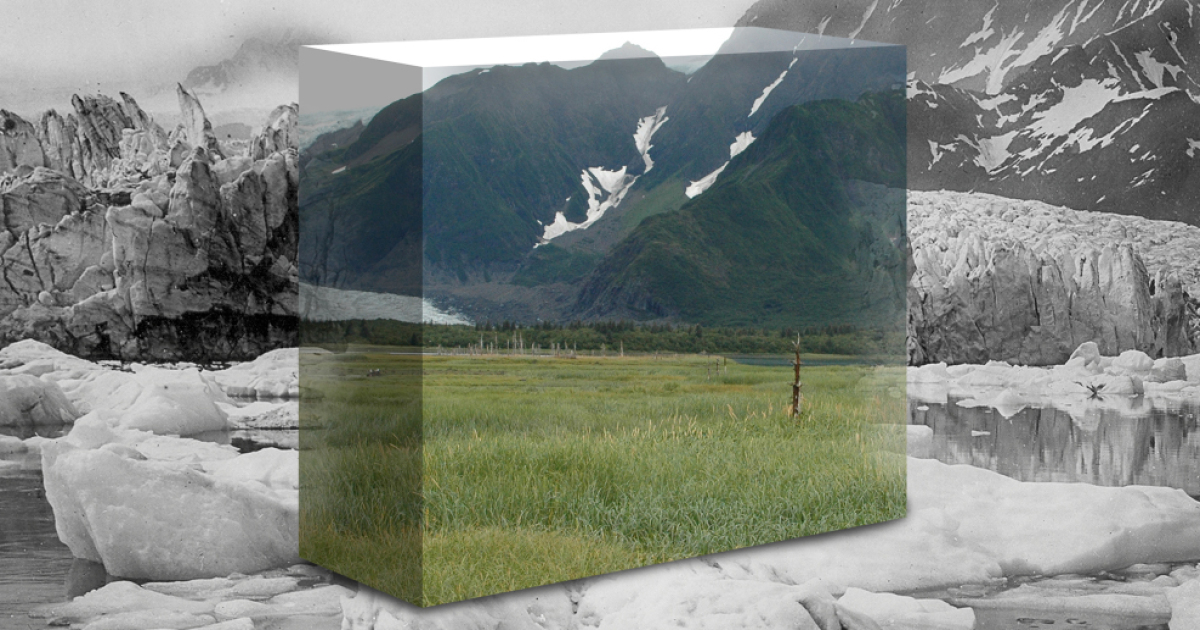
The series includes comparisons involving Carroll Glacier, Yalik Glacier, Pedersen Glacier, and Muir Glacier. The time spans range from roughly six decades to nearly a century. In each composition, the past and present occupy the same visual field, making long-term change readable at a glance.
Carroll and Yalik: Nearly a Century in One Frame
The Carroll Glacier comparison covers about 98 years, while the Yalik Glacier image spans about 95 years. These long records move the discussion beyond one warm summer or a conveniently selected news cycle. In the older scenes, ice occupies space that later becomes water, bare land, or vegetation. The landscape has not simply changed color; its physical structure has changed.
A glacier is a moving system. Snow accumulates, ice flows downhill, and mass is lost through melting, runoff, evaporation, and calving. When loss repeatedly exceeds accumulation, the glacier becomes thinner and its terminus retreats, even if an unusually snowy season briefly improves the balance.
Pedersen and Muir: Familiar Places, Different Landscapes
The Pedersen Glacier appears in comparisons spanning approximately 88 years and 65 years, including a historic scene where seals rested on ice in a place that later looked strikingly different. Muir Glacier is shown across about 63 years. These images reveal more than a moving ice edge; they show changing water boundaries, ecological succession, and terrain that had long been hidden.
When paired with dates, locations, and credible source information, repeat photographs become more than dramatic scenery. They are visual records that a classroom, newsroom, museum, or community group can understand without requiring everyone to complete a graduate seminar in glaciology before lunch.
“`
The Science Behind Alaska’s Vanishing Ice
“`
Glaciers Keep a Simple but Unforgiving Budget
A glacier survives through mass balance. Snow and ice are added, while melting, runoff, evaporation, and calving remove material. If accumulation exceeds loss, the glacier gains mass. If loss exceeds accumulation over many years, it thins and retreats. The concept is simple; measuring it requires field stakes, aerial surveys, satellites, historical photographs, and plenty of cold fingers.
Air temperature is a major driver of surface melt. Snowfall and ocean conditions also influence particular glaciers. Coastal glaciers may respond strongly to warm water and calving dynamics, while inland glaciers can be especially sensitive to summer heat and winter precipitation. Scientists therefore monitor many glaciers over long periods instead of treating one glacier in one season as a stand-in for the planet.
Alaska’s Glacier Loss Has Global Consequences
Alaska’s glaciers are far smaller than the Greenland and Antarctic ice sheets, yet their collective contribution to sea-level rise is substantial. Meltwater entering the ocean raises global average sea level, although local changes vary because currents, gravity, land motion, and coastal geology complicate the picture.
In parts of southeast Alaska, for example, land is rising as it rebounds from the weight of former ice, so local relative sea level may differ from the global trend. That does not cancel global sea-level rise. It simply proves that Earth science enjoys answering simple questions with several footnotes.
Recent global records show that glacier loss is not an old problem preserved in sepia photographs. During the 2025 hydrological year, glaciers worldwide lost hundreds of gigatons of mass, and several of the highest-loss years in the modern record occurred within the previous seven years. Historic images explain where the process has been; current measurements show that it continues.
Retreat Changes Water, Wildlife, and Communities
As Alaska glaciers shrink, downstream water systems can change in timing, volume, temperature, and chemistry. Glacial lakes may grow and occasionally release sudden floods. Newly exposed slopes can become unstable, rivers may shift course, and marine or freshwater habitats may be altered.
Those changes affect fish, birds, mammals, tourism businesses, public safety, and communities whose food systems and cultural traditions are tied to ice-fed landscapes. The same retreat can reveal a beautiful blue lake while increasing a flood hazard. Nature is under no obligation to organize its consequences into a tidy brochure.
“`
Why I Am Offering the Climate Images for Free Use
“`
Climate communicators often work with limited budgets. A teacher may need a strong visual for tomorrow morning’s lesson. A local nonprofit may be building a presentation with volunteer help. A scientist may have excellent data but no image that invites a general audience into the subject. Licensing costs can become one more barrier between accurate information and the people who need it.
Making the series available for climate-related communication lowers that barrier. The images can support lessons about glacier retreat, public talks, community planning, museum displays, articles, social posts, research presentations, and nonprofit campaigns.
Free use, however, does not mean ownerless use. The credit and source information included on each image must remain visible in online and printed publication. That condition protects the photographers and archives behind the historical material, preserves the chain of evidence, and helps viewers understand where the comparison came from. Cropping out the attribution is not a clever design choice. It is the visual equivalent of borrowing someone’s car and sanding off the license plate.
“`
How to Use Glacier Images Responsibly
“`
Keep the Context Attached
Include the glacier name, dates, source credits, and a short explanation of what viewers are seeing. Avoid claiming that every visible detail came from one cause when research identifies several influences. Human-driven warming explains widespread glacier loss, while local snowfall, ocean temperature, topography, and ice dynamics shape each glacier’s response.
Use the Correct Ice Vocabulary
Glaciers form on land and flow under their own weight. Ice sheets are enormous land-ice systems covering Greenland and Antarctica. Sea ice forms when ocean water freezes. Melting land ice directly contributes to sea-level rise; melting floating sea ice does not raise sea level in the same direct way, though its decline affects climate, ecosystems, and ocean heat absorption. Correct terminology builds trust and keeps an otherwise useful post from wandering into the comments section wearing clown shoes.
Pair Urgency With Agency
Images of disappearing ice can create concern, sadness, or anger. Good communication connects those emotions to meaningful action: cleaner energy, efficient buildings, lower-emission transportation, methane reduction, habitat protection, resilient infrastructure, community preparedness, education, and support for sound public policy.
The goal is not to soften reality. It is to prevent reality from feeling so enormous that people decide their only option is staring into the refrigerator with the door open. Name the problem, explain why it matters, and offer a practical next step.
Make the Material Accessible
Add descriptive alt text, readable captions, and plain-language definitions. Use high contrast and provide image descriptions in presentations. Localize the message when possible: coastal audiences may connect through sea-level risk, while inland communities may connect through water, wildfire, wildlife, tourism, or changing ecosystems.
“`
Why Art Belongs Beside Climate Science
“`
Science establishes what is happening. Art helps people stay with that knowledge long enough to feel its scale. A carefully sourced image does not replace measurements, and a spreadsheet does not replace human attention. They work best together.
Repeat glacier photography is powerful because it respects the viewer’s ability to observe. The matching ridgeline, valley, or shoreline provides continuity; the missing ice provides the argument. At the same time, Alaska should not be treated as an empty stage for dramatic climate posters. It is home to Indigenous communities, working towns, wildlife, protected lands, and living relationships with ice-fed ecosystems. Responsible imagery recognizes those human and cultural connections.
“`
My Experience Creating and Sharing the Melting Glaciers Series
“`
Creating this series changed the way I thought about time. I had long worked with a visual technique that combines photographs of the same scene taken at different moments, but glacier comparisons carried a different emotional weight. In an ordinary city image, the changes might be new buildings, different cars, or a tree that grew large enough to block a sign. With glaciers, the missing subject was sometimes the largest object in the frame.
The first challenge was not dramatic or poetic. It was research. I needed historic and modern images that could be legally used, accurately identified, and aligned closely enough to create a meaningful comparison. Old photographs do not arrive with modern metadata neatly tucked into their coats. Dates, locations, photographers, archives, and rights all have to be checked. A beautiful image with uncertain provenance is not useful for a project built around evidence.
Matching viewpoints was another lesson in patience. Two photographers can stand near the same place and still create scenes that resist alignment because of lens choice, camera height, season, weather, or changes in access. Mountain ridges became my most dependable guides. They do not hold perfectly still on geological time scales, but they are wonderfully cooperative during a digital editing session.
Once the images began to overlap, the project became more emotional. A statistic tells the mind that ice has been lost. A blended comparison shows the eye where it used to be. I could trace former glacier boundaries across water, rock, grass, and young vegetation. In the Pedersen scene with seals, the change felt particularly intimate. Animals resting on ice in the historic view occupied a world that the later photograph no longer offered in the same form.
I also became more aware of the responsibility involved in making a persuasive image. Digital art can clarify a comparison, but it can mislead if the process hides dates, exaggerates scale, removes context, or treats source material casually. I wanted the compositions to be visually arresting without becoming visual tricks. The credits are therefore not decorative fine print; they are part of the work’s credibility.
Offering the series for free climate-related use was the natural final step. I did not want the images to sit quietly in a portfolio while teachers, organizers, scientists, and writers searched for affordable ways to explain the same issue. Art becomes more useful when it travels. A classroom slide, community meeting, research talk, or local article may reach people who never encounter the original series.
The experience taught me that one image rarely changes everything. Climate communication is cumulative. A photograph creates attention. A caption supplies context. A trusted speaker builds understanding. A practical action turns concern into participation. The picture is not the entire conversation; it is an open door.
Most of all, the series left me with a mixture of awe and grief. Alaska’s glacier landscapes remain magnificent. Their beauty is not proof that everything is fine. Sometimes beauty makes loss harder to recognize because the transformed landscape can still take your breath away. The series holds both truths at once: these places are extraordinary, and they are being profoundly changed.
“`
Conclusion: Let the Images Start a Better Conversation
“`
Melting Alaskan glaciers are among the clearest visual records of a warming climate. Their retreat affects landscapes, waterways, ecosystems, communities, and global sea level. Historic and modern photographs make those changes understandable in a way that numbers alone sometimes cannot.
By releasing these digital comparisons for free climate communication, I hope to give educators, journalists, nonprofits, researchers, and advocates a practical tool. Use the images accurately. Preserve every required credit and source line. Add clear captions. Connect the visible change to credible science and realistic solutions.
A glacier comparison cannot write policy or prepare a community for flooding. It can make someone pause. That pause can become a question, the question can become understanding, and understanding can become action. For a piece of digital artand for a very quiet river of icethat is a worthwhile job.
“`

